Wednesday, April 12, 2023

Top 15 largest empires in history


This is the list of the top 15 largest empires by land area at their greatest extent.

Number 15:

German Empire Map

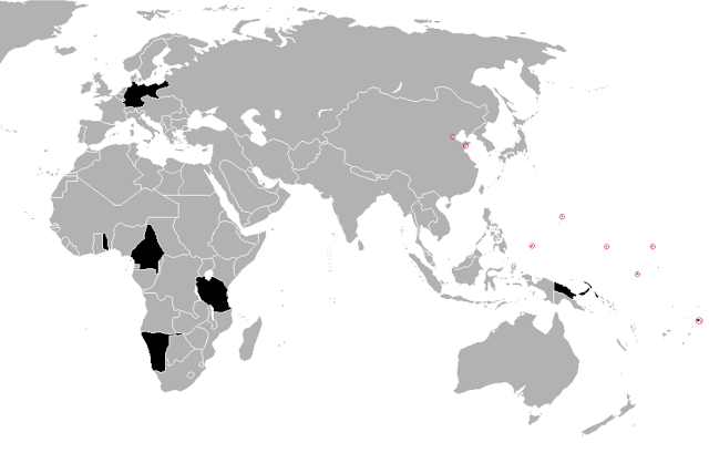
The German colonial empire, before the start of the First World War, with a surface of 3.2 million km2. 

Third Reich

Also known as the "Second Reich", It was founded on 1 January 1871 when the south German states, except for Austria, joined the North German Confederation. The German colonial empire included Germany, Cameroon, Namibia, Tanzania, German New Guinea, and some islands in the Pacific Ocean.

During the Second World War, at its greatest extent, in November 1942, the Third Reich, with a surface of 3.6 million km2 was bigger than The German colonial empire, but it lasted for a very short time.

Number 14:

The Italian Empire

The Italian Empire, in the spring of 1941, with a surface of 4.2 million km2. Although they had a much weaker army than the Germans, the territory controlled by the Italians during World War II was larger. Outside Italy, in Europe, they owned Albania, the Dalmatian coast, western Greece, and in Africa, Libya, Somalia and Ethiopia, along with other smaller territories. By the autumn of 1943, the Italian Empire disappeared, after the allies occupied their territories in Africa, and the southern half of Italy.

Number 13:

The Mughal Empire

The Mughal Empire, at the beginning of the 18th century, with a surface of 4 million km2, and a population of 160 million people. The Mughal Empire is conventionally said to have been founded in 1526 by Babur, a warrior chieftain from Central Asia. At its greatest extent, it was one of the largest empires in the history of South Asia, stretching from northern Afghanistan in the northwest, to Bangladesh in the east, and the Deccan plateau in the South. The empire subsequently fragmented after 1720, and was dissolved by the British Raj after the Indian Rebellion of 1857.

Maurya Empire
Delhi Sultanate

Other great empires that had their center in India were the Maurya Empire, with a surface of about 4 million km2 around the year 250 BC, and the Delhi Sultanate with a surface of about 3.2 million km2 around the year 1330.

Number 12:

The Roman Empire

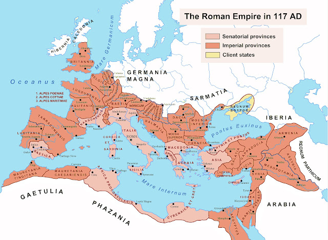
The Roman Empire, at the death of emperor Trajan in 117 AD, with a surface of 5 million km2, and a population of 60 million people. The Roman Empire was the only state that held all the territories around the Mediterranean Sea, this sea being called "Mare Nostrum" (Our Sea). 


After the death of Emperor Theodosius in 395, the empire was permanently divided between his sons Arcadius and Honorius, in the Western Roman Empire and the Eastern Roman Empire. 

Byzantine Empire

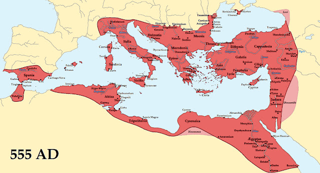
The Western Roman Empire collapsed in 476, while the Eastern Roman Empire was transformed into the Byzantine Empire, reaching its maximum territorial expansion in 555, during the reign of Justinian I.

Number 11:

The Ottoman Empire

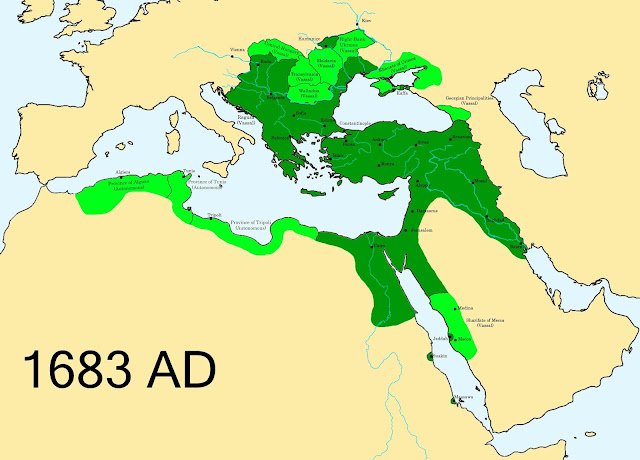
The Ottoman Empire, before the Siege of Vienna in 1683, with a surface of 5.2 million km2. This empire controlled much of Southeast Europe, Western Asia and North Africa between the 14th and early 20th centuries. 

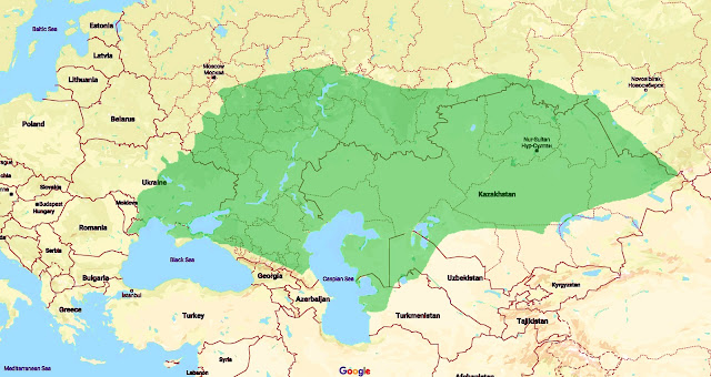
Göktürk Khaganate

Apart from the Ottoman Empire, the Turks built other lesser-known empires, such as the Göktürk Khaganate, with a surface of about 6 million km2 around the year 570 BC, and the Seljuk Empire, with a surface of about 3.9 million km2 , upon the death of sultan Malik Shah I in 1092.

Number 10:

The Achaemenid Empire

The Achaemenid Empire, during the reign of Darius I, with a surface of 5.5 million km2. This Persian Empire, ranging at its greatest extent from the Balkans in the west to the Indus Valley in the east, was a successful model of a centralised, bureaucratic administration. 


Most of the empire was conquered by Alexander the Great by 330 BC. Alexander's empire at his death in 323 BC had a surface of about 5.2 million km2. A Neo-Persian Empire under the Sassanid dynasty has reached a surface of 3.5 million km2 around 620 AD.

Number 9:

The Empire of Japan in 1942

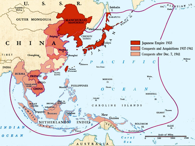
The Empire of Japan in 1942 with a surface of 8.5 million km2. Japan was a great power after the Meiji Restoration in 1868. Victories over China and Russia expanded the Japanese sphere of influence, notably in Taiwan, Korea, and southern Sakhalin island. With the Japanese expansion into Manchuria in the early 1930s, Japan adopted a policy of setting up puppet states in conquered regions. Japan controlled many of the states of what it referred to as the Greater East Asia Co-Prosperity Sphere, a concept which gradually formed under Japanese influence from 1930 to 1945.

Number 8:

The Portuguese Empire

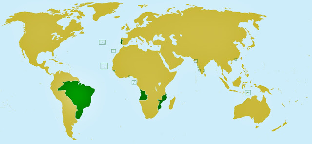
The Portuguese Empire in 1820, with a surface of 10.4 million km2. The Portuguese Empire was the first global empire in history, after the capture of Ceuta in 1415. The empire's most valuable colony, Brazil, won its independence in 1822. After the First World

The Portuguese Empire
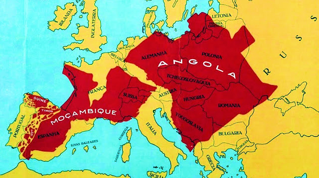
War, the empire reached a surface of 2.2 million km2, with Angola and Mozambique as its most important colonies. Following the Carnation Revolution in 1974, the empire's government recognized the independence of all its colonies in less than a year, except for Macau who was returned to China in 1999.

Number 7:

The second French colonial empire

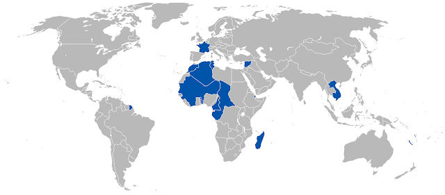
The second French colonial empire, after the First World War, with a surface of 11.5 million km2, and a population of 110 million people in 1939. The "second colonial empire", began with the conquest of Algiers in 1830, concentrating chiefly in Africa as well as Indochina and the South Pacific.

The First French colonial empire

The "first French colonial empire," which existed until 1814, was much smaller, reaching its peak during the Seven Years' War in 1760 with a surface of 3.4 million km2.

Number 6:

The Arab Caliphate

The Arab Caliphate under the Umayyad dynasty in 750, with a surface of 13.4 million km2 . The Arab conquests began with the Islamic prophet Muhammad in the 7th century, who established a new state in the Arabian Peninsula. The Caliphate grew rapidly in territory, stretching from the Iberian Peninsula in the west to the Indus valley in the east, across Nord Africa and Middle East. After 850, the empire was fragmented into independent emirates, which were ruled for the next centuries by local dynasties.

Number 5:

Qing dynasty

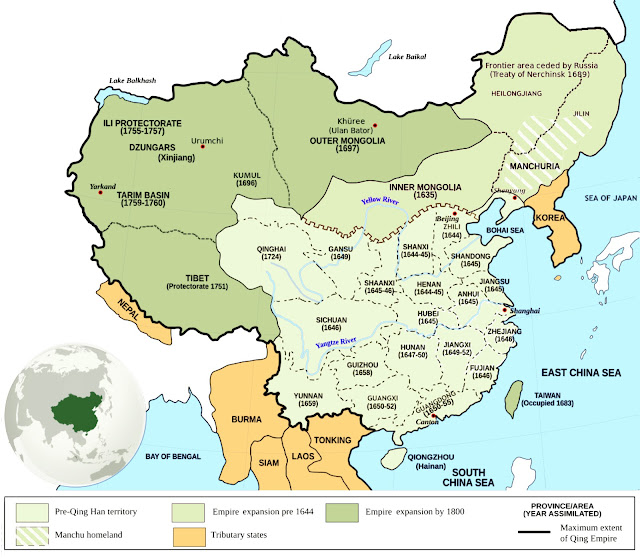
The Chinese Empire, under the Qing dynasty at the end of the 18th century, with a surface of 13.5 million km2 and a population of 300 million people. The Qing dynasty was the last imperial dynasty of China, ruling the country from 1644 to 1911. During the peak of the Qing dynasty, the empire ruled over the entirety of today's Mainland China, Hainan, Taiwan, Mongolia, Outer Manchuria and Outer Northwest China.

Han dynasty

Other dynasties under which the Chinese Empire reached considerable dimensions were Han dynasty around the year 100

 the Yuan dynasty
AD (6.5 million km2), The Tang dynasty in 669 AD (10.8 million km2), the Yuan dynasty around 1330 (13.7 million km2), and the Ming dynasty around 1450 (6.5 million km2).

Number 4:


The Spanish Empire in 1790, with a surface of 15.8 million km2 and a population of 60 million people. After the discovery of America in 1492, Spain explored and conquered large tracts of territory on this continent. The Philippines, Marianas, Carolines, and small territories in Africa were also conquered. The American colonies were lost at the beginning of the 19th century, and the colonies in the Pacific in 1898. 

the Iberian Union

Between 1580 and 1640 was a dynastic union of the Kingdom of Portugal and the Spanish Crown. The area of the territories claimed by the Spanish Empire during the Iberian Union was 26.9 million km2, but in reality, the area actually controlled was much smaller, only 7.1 million km2.

Number 3:

The Russian Empire around the year 1900

The Russian Empire around the year 1900, with a surface of 22.8 million km2 and a population of 135 million people. Russia became an independent state in 1480, during the reign of Tsar Ivan III, and a major European power during the reign of Peter the Great. At the beginning of the 20th century, the Russian Empire extended from the Arctic Ocean in the north to the Tien Shan mountains in the south, from the Polish Plains in the west to the Pacific Ocean, in the east. It lasted until it was declared a republic in March 1917 after the Russian Revolution.

The Soviet Union

The Soviet Union had a slightly smaller surface than the Russian Empire, 22.4 million km2 after the Second World War, and a population of 293 million people in 1991.

Number 2:

The Mongol Empire in 1309

The Mongol Empire in 1309, with a surface of 24 million km2. It emerged from the unification of several nomadic tribes in the Mongol homeland under the leadership of Genghis Khan, and it expanded from Central Europe in the West, to Pacific Ocean in the East, from Siberia in the north to India and the Persian Gulf in the south.

The Xiongnu Khanate

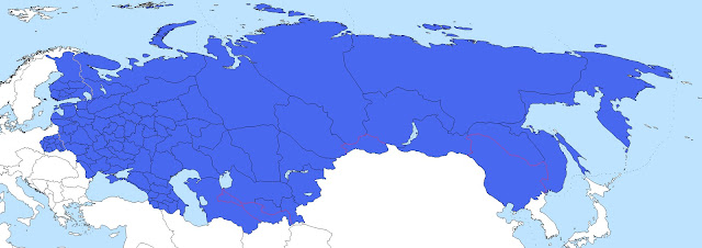
Other Mongol Empires that reached considerable dimensions were The Xiongnu Khanate around 200 BC (9 million km2), The Golden

The Golden Horde Khanate
Horde Khanate in 1310 (6 million km2), and the Timurid Empire around 1405 (4.4 million km2).

Number 1:

The British Empire

The British Empire after the First World War, with a surface of 35.5 million km2 and a population of 550 million people in 1939. It originated with the overseas possessions and trading posts established by England between the late 16th and early 18th centuries. The British Empire expanded to include Canada, Australia, most of India, large parts of Africa and many other territories throughout the world. At the peak of its power, the phrase "the empire on which the sun never sets" was often used to describe the British Empire.
The Belgae Tribes and the Roman conquest of Belgium


The Belgae were a group of tribes living in northern Gaul, on the west bank of the Rhine, from at least the third century BC. They gave their name to the Roman province of Gallia Belgica, and very much later, to the modern country of Belgium.

From 500 BC Celtic tribes settled in the region of present day Belgium, and traded with the Mediterranean world. The Roman influence penetrated into those areas about 150 BC., when the first coins came into use.

Julius Caesar
Julius Caesar describes Gaul at the time of his conquests (58–51 BC) as divided into three parts, inhabited by the Aquitani in the southwest, the Gauls of the biggest central part, and the Belgae in the north. Each of these three parts was different in terms of customs, laws, and language.

He noted that the Belgae, were "the bravest, because they are furthest from the civilization and refinement of [our] Province, and merchants least frequently resort to them, and import those things which tend to effeminate the mind; and they are the nearest to the Germans, who dwell beyond the Rhine , with whom they are continually waging war".
Gallia map

For a long time the Belgae were considered to be Gallic people, or a Germanic people dominated by a Gallic aristocracy (hypothesis suggested by the fact that the names of the Belgae chiefs are of Celtic origin, as well as ancient and non-Germanic toponyms).
Belgae house

More precise analyzes of the names of the tribes, their chiefs and their gods lead to these various assumptions: some tribes would be genuinely Gallic (such as the Remi, the Bellovaci, the Morini or the Atrebates), others would show Germanic features (Nervii, Aduatuci, Condrusi, Menapii, Treveri ...) according to Caesar.

Caesar reported that the more northerly allies of the Belgae, from west to east the Menapii, Nervii, and Germani cisrhenani, were less economically developed and more warlike, similar to the Germani east of the Rhine river. The Menapii and northern Germani lived among low thorny forests, islands and swamps, and the central Belgian Nervii lands were deliberately planted with thick hedges, in order to be impenetrable to cavalry.
Belgae in England

During the late 2nd or early 1st century bc, a small group of Belgae crossed to Britain. After further Gallic victories by Caesar, other settlers took refuge across the Channel, and Belgic culture spread to most of lowland Britain. The three most important Belgic kingdoms, identified by their coinage, were centred at Colchester, St. Albans, and Silchester. The chief Belgic contribution to southern Britain was the introduction of the heavy plow, which was used to clear many lands previously untillable.

Caesar writes that the Belgae were conspiring and arming themselves in response to his earlier conquests; to counter this threat, he raised two new legions and ordered his Gallic allies, the Aedui, to invade the territory of the Bellovaci, the largest and fiercest of the Belgae tribes, in 57 BC.

Cautious of the numbers and bravery of the Belgae, Caesar initially avoided a pitched battle, resorting mainly to cavalry skirmishes to probe their strengths and weaknesses. Once he was satisfied his troops were a match for them, he made camp on a low hill protected by a marsh at the front and the river Aisne behind, near Bibrax (between modern Laon and Reims) in the territory of the Remi.
Belgae attack

The Belgae attacked over the river, but were repulsed after a fierce battle. Realising they could not dislodge the Romans and aware of the approach of the Aedui into the lands of the Bellovaci, the Belgae decided to disband their combined force and return to their own lands. Caesar's informants advised him that whichever tribe he would attacked first, the others would come to their defence. At daybreak, Caesar sent his cavalry to harass the rear guard of the Belgae, killing many of them.
Caesar next marched into the territory of the Suessiones and besieged the town of Noviodunum (Soissons). Seeing the Romans' siege engines, the Suessiones surrendered, whereupon Caesar turned his attention to the Bellovaci, who had retreated into the fortress of Bratuspantium (between modern Amiens and Beauvais). They quickly surrendered, as did the Ambiani.
roman camp on hill

The Nervii, along with the Atrebates and Viromandui, decided to fight. They concealed themselves in
angry Caesar attack
the forests and attacked the approaching Roman column at the river Sabis.  Their quick and unexpected attack left the Romans exposed. However, Caesar grabbed a shield, made his way to the front line, and quickly organised his forces. The two Roman legions guarding the baggage train at the rear finally arrived and helped to turn the tide of the battle. Caesar says the Nervii were almost annihilated in the battle, and is effusive in his tribute to their bravery, calling them "heroes".

The Atuatuci, who were marching to their aid, turned back on hearing of the defeat and retreated to one stronghold, were put under siege, and soon surrendered and handed over their arms. However, the surrender was a ploy, and the Atuatuci, armed with weapons they had hidden, tried to break out during the night. The Romans had the advantage of position and killed 4000. The rest, about 53 thousand, were sold into slavery.
Ambiorix

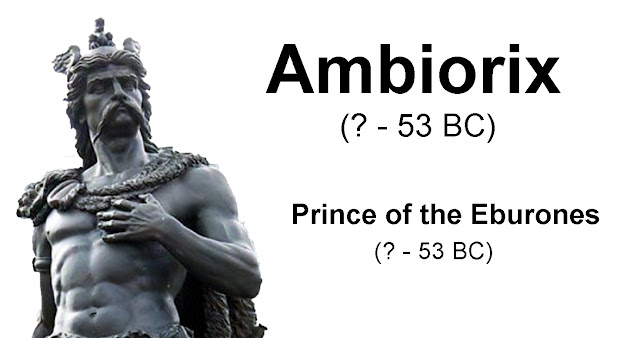
In 53 BC, the Eburones, led by Ambiorix, along with the Nervii, Menapii, and Morini, revolted again and wiped out 15 cohorts, only to be put down by Caesar. The following year, Belgae fought again, in the uprising of Vercingetorix.
Vercingetorix

After their final subjugation, Caesar combined the three parts of Gaul, the territory of the Belgae, Celtae, and Aquitani, into a single unwieldy province (Gallia Comata, "long-haired Gaul").

The Carnation Revolution in Portugal


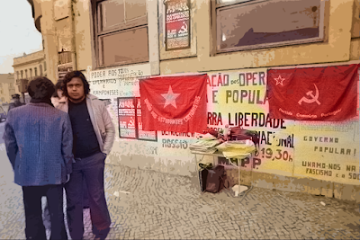
The Carnation Revolution took place in Portugal on 25 April 1974, when a group of young officers overthrew the Estado Novo dictatorship, which has been in force since 1933. Its name arose from the fact that almost no shots were fired, and the population who took the streets to celebrate the end of the dictatorship offered carnations to the soldiers, which were placed in the muzzles of guns and on the soldiers' uniforms.

The April Revolution initiated a process that would eventually end with the establishment of a democratic regime in Portugal and the entry into force of a new constitution in 1976.

Since 1933, Portugal had been governed by an authoritarian dictatorship, the Estado Novo or New State, which evolved from the Ditadura Nacional (National Dictatorship) set up after the 28 May

One of the driving forces that led to the Carnation Revolution was a desire to end colonization in Africa, especially in light of the violent and costly Portuguese Colonial War. The Independence movements from the Portuguese Mozambique, Portuguese Congo, Portuguese Angola, and Portuguese Guinea forced the Salazar and Caetano regimes to spend more of Portugal's budget on colonial administration and military expenditure, and the country became increasingly isolated from the rest of the world.

salazar
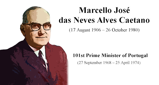
1926 coup d'etat. Characterized as an authoritarian government, it was a time of censorship and oppression and maintained by a “secret police” force. António de Oliveira Salazar was prime minister until 1968, when he had a stroke, and was replaced by Marcello Caetano.
Marcello Caetano

Thousands of young men avoided conscription by emigrating illegally, primarily to France and the United States. In the early 1970s began the revolutionary Armed Forces Movement as an attempt to liberate Portugal from the Estado Novo regime and challenge the new military laws which would reduce the military budget and reformulate the Portuguese military.
António de Spínola

In February 1974, Caetano decided to remove General António de Spínola from the position of Vice-Chief of the Defence Council of the Armed Forces in the face of Spínola's increasing disagreement with the promotion of military officers and the direction of Portuguese colonial policy. This occurred shortly after the publication of Spínola's book, Portugal and the Future, which expressed his political and military views of the Portuguese Colonial War.
Armed Forces Movement leaders

In March, the leaders of the Armed Forces Movement decided when to overthrow the government. The coup began with the airing of Portugal’s song from the 1974 Eurovision competition, Paulo de Carvalho's "E Depois do Adeus" on 24 April at 10:55 p.m. This alerted the rebel captains and soldiers to begin the coup. The second signal came at 12:20 a.m. on 25 April, when Rádio Renascença broadcast "Grândola, Vila Morena", a song banned from Portuguese radio at that time. This was the signal for the rebels to begin to take over strategic points in the country.

At 4:20 AM the rebels broadcasts their first radio announcement. Commanders of forces loyal to the government were arrested in the morning, and their troops joined the rebels.
carnation revolution

Despite repeated radio appeals from the rebel leaders, advising the population to stay home, thousands of Portuguese took to the streets, to support the military insurgents. A central gathering point was the Lisbon flower market, then richly stocked with carnations (which were in season). Some of the insurgents put carnations in their gun barrels, an image broadcast on television worldwide which gave the revolution its name.

Caetano found refuge in the main Lisbon military police station at the Largo do Carmo. Caetano, who surrenders at the end of the day, was demanding, however, that the power to be handed over to General Antonio de Spinola, that was not part of the Armed Forces Movement. Marcelo Caetano was flown under custody to the Madeira Islands where he stayed for a few days, before he  flew for exile in Brazil.
the Ongoing Revolutionary Process

After the coup, power was held by the National Salvation Junta. Portugal experienced a turbulent period, known as the Ongoing Revolutionary Process. One of the first acts of the new government was to end the colonial wars and negotiate Portuguese withdrawal from its African colonies. These events prompted a mass exodus of Portuguese citizens from Portugal's African territories, creating over a million Portuguese refugees – the retornados.

Spínola lasted as the first post-Revolution President from 15 May 1974 until 30 September of the same year, when he resigned after the failed coup planned by Right-wing military figures on 28 September 1974. On 25 November 1975 was a pro-communist coup, followed by a successful counter-coup by pro-democracy moderates.
Mário Soares

The Ongoing Revolutionary Process ended after the entry into force of the new Constitution on April 25, 1976, and the first constitutional government, led by centre-left socialist Mário Soares, took office.

Tuesday, April 11, 2023

Principality of Theodoro (Mangup) - the last Byzantine state

        
The Principality of Theodoro also known as Gothia, or the Principality of Mangup, was a small, Christian feudal state in the southwestern part of Crimea, which existed from the 13th century to the 15th century. Its capital was Doros, also sometimes called Theodoro and now known as Mangup.
Gothia's population was a mixture of Greeks, Crimean Goths, Alans, Bulgars, Cumans, Kipchaks and other ethnic groups, most of whom were adherents to Orthodox Christianity and Hellenized. The principality's official language was Greek.
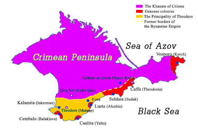
Principality of Theodoro map

The principality was a successor state of the Byzantine Empire, and was formed at the beginning of the 13th century from that part of the former Byzantine theme of Kherson in the Crimea, which had not become a colony of Genoa.
Trebizond Empire

In 1204, during the fourth crusade, the Venetians seized the best Byzantine ports: Cembalo, Soldaia and Caffa. The remainder of the theme falls to the Greek Empire of Trebizond (located on the other side of the Black Sea, and ruled by the Komnenos, then, in 1235, to the Greek Empire of Nicaea (governed by the Paleologues).

This dependence was never very strong and was eventually replaced by the invading Mongols, who in 1238 poured into the peninsula, occupied its east and enforced a tribute on the western half, including Gothia. Apart of said tribute their influence was limited, leaving administrative matters in native hands.
Mongol Khagan Möngke

Mongol Khagan Möngke grants Caffa, Chimmero and Vosporo to the Genoese. Then, the Genoese obtained two other ports, Lusta and Caulita, in 1315 from the Greek Empire of Nicaea, in exchange for loans.

During this period, besides the Greeks of the Black Sea, Cherkessogais Armenians populate the region, as evidenced by the presence of many churches and Armenian monasteries such as that of the Holy Cross of Sourkhat.
Demetrios Palaeologus-Gabras

In 1362, Demetrios Palaeologus-Gabras, founded The Armenian-Byzantine ruling dynasty of the Gabras, which was related by marriage with the Komnenos and the Paleologues. They bore the title of "Prince of Theodoro and Gothia". This dynasty makes of Theodoros an independent principality, which resists the Tatars and disputes with the Genoese the control of the coast.
Tamerlane

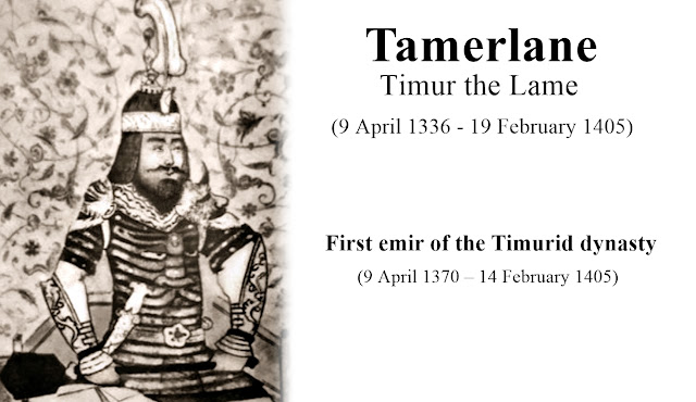
In 1395 the warlord Tamerlane invaded the Crimean peninsula, destroying several towns including Gothia's capital Theodoro. After his death in 1404 the Principality of Theodoro grew to become one of the most significant powers of the Black Sea, profiting from a period of Genoese instability and its neglect of its Black Sea colonies, but also the rise of the Crimean Khanate. In 1432 the Principality of Theodoro sided with Venice against Genoa due to the latter's promise to grant them access to the sea.
The principality had peaceful relations with the Golden Horde to its north, paying an annual tribute as vassals, but was in constant strife with Genoese Gazaria colonies to the south over access to the coasts and the trade that went through the Crimean harbours. A narrow strip of the coastal land from Balaklava in the west to Alushta in the east initially part of the principality soon fell under Genoese control. After they had lost harbours on the southern coast Theodorites built a new port called Avlita at the mouth of the Chernaya River and fortified it with the fortress of Kalamita.
Isaac Paleologue-Gavras

After the conquest of Constantinople in 1453 by the Ottomans, the capture of the despotate of Morea in 1460 and the Empire of Trebizond in 1461, Theodoro was the last Byzantine country to retain its political independence.
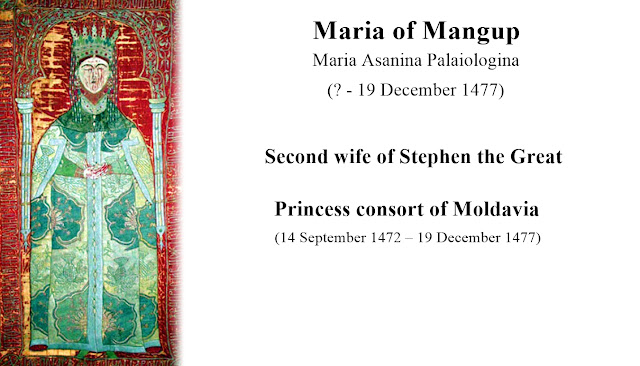
Marie of Mangop

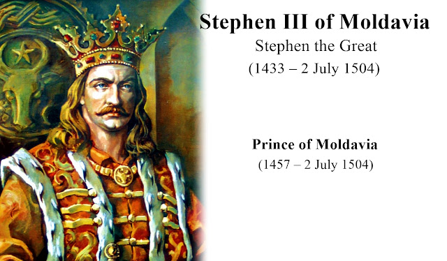
In the face of the mounting Ottoman danger, Isaac Paleologue-Gavras engaged in a reconciliation with the Genoese, and arrange a marriage between his sister Marie, and Stephen the Great, ruler of Moldavia in 1472. However, Isaac still isolated between Sultan Mehmed II and the Khan of Crimea, chose, in order to safeguard the autonomy of his principality, to recognize himself vassal of the Ottoman Empire.
Stephen the Great

Fearing this change of alliance, Stephen the Great has the idea to provide Alexander, a brother of Isaac, a small fleet and a contingent of 300 Moldovan soldiers to join Theodoro, where they dethrone and kill Isaac.
Sultan Mehmed II

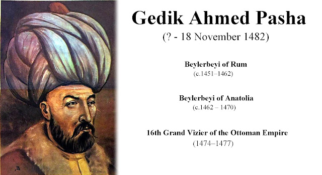
The reign of the new sovereign of Theodoros, installed by the Moldavians, is very short, because the Ottomans, allied with the Tatars and commanded by Pasha and Vizier Gedik Ahmed invaded Crimea in May 1475. In December 1475, after conquering the other Christian strongholds along the Crimean coast, the Ottomans captured the city of Theodoro after a three-month siege.
Gedik Ahmed

Alexander and his family were taken captive to Constantinople, where the prince was beheaded. His son was forcibly converted to Islam, and his wife and daughters became part of the Sultan's harem.
Map after conquest of Theodoro

Principality of Theodoros became an Ottoman province, while the northern peninsula remain part of the Crimean khanate, vassal of the Sublime Porte.  The principality of Theodoros is the last Byzantine state to disappear, 22 years after the fall of Constantinople.